

Geostrategic Approaches of the World’s Major Powers
Exploring Critical Waterways, Regional Barriers, and Power Dynamics in a Shifting World Order

Geography plays a huge role in shaping a country's strategy.
Since there are no natural barriers in the west, Russia keeps a large military force stationed there.
Because European countries are relatively small, they have chosen to band together for greater strength and influence.
With its unique geography offering both land and sea advantages, China is working to develop its capabilities on both fronts.
America's rise was swift, thanks to the oceans that shielded it. But now, its deep involvement in global affairs has become a burden.
This article will kick off by diving into the world's most critical waterways. From there, we'll zoom in on the unique geographical spots where different regions and countries sit, unpacking how these locations shape their development strategies.
1.Eight critical maritime routes sustaining global commerce
Let's dive into the world's major shipping routes. There are eight key players here: the North Atlantic Route, the Asia-Europe Route (known as the Suez Canal Route), the Cape of Good Hope Route, the Panama Canal Route, the North Pacific Route, the South Pacific Route, the South Atlantic Route, and the Arctic Route.
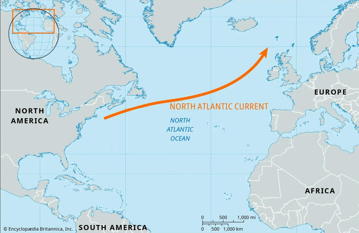
1.1 North Atlantic route
The North Atlantic route, connecting the east coast of North America with the west coast of Europe, is a critical artery for global trade. It carries the highest volume of high-end manufacturing goods worldwide, including automotive parts from the US, precision machinery from Europe, and consumer goods shipped across the Atlantic.
Meanwhile, this shipping route also moves NATO military gear across the ocean. It has the most advanced port systems, making it the main artery of global trade.
1.2 Asia-Europe route
The Asia-Europe shipping route is 40% shorter than the Cape of Good Hope route, making it the preferred choice for container shipping between Asia and Europe.
It primarily handles electronic goods from China, Middle Eastern oil, and Southeast Asian textiles.
But the canal's too small for those giant cruise ships to slip through. And it runs through some sketchy spots like the Red Sea, where piracy and political unrest are always a threat.
1.3 Cape of Good Hope route
The Cape of Good Hope route is the only long-distance shipping lane that doesn't depend on man-made canals. It carries crude oil across the globe, along with South African gold and Brazilian iron ore.
It can handle those giant cargo ships no problem. However, compared to the Suez Canal, it's a longer haul—adding 7 to 10 days to the trip and bumping up fuel costs by about 30%.
The Suez Canal has seen many accidents involving massive ships due to weather conditions. Therefore, the Cape of Good Hope route serves as a key backup when the canal gets blocked.

1.4 The Panama Canal route
The Panama Canal route connects the Pacific and Atlantic Oceans, making it a breeze to ship goods between the east and west coasts of the Americas.
Its core cargo includes corn from the U.S. Midwest, refined copper from Chile, and consumer goods from Asia heading to the U.S. East Coast.

1.5 The North Pacific route and the South Pacific route
The North Pacific route is a manufacturing corridor linking East Asia to North America's coast. It's main goods are electronics, cars, and high-end machinery.
Australia and New Zealand serve as key hubs in the South Pacific route, creating a transport network that moves Oceania's resources to Southeast Asia and South America's west coast.
With the Indo-Pacific economic framework picking up steam, this route's importance is only growing.
1.6 The South Atlantic route
The South Atlantic route is a cross-hemisphere passage connecting South America's east coast to Africa's west coast. Its core goods are Brazilian soybeans, Argentine beef and Nigerian crude oil.
Affected by climate conditions, certain sections of this shipping route experience average annual wave heights exceeding 4 meters.
Additionally, the port infrastructure along the West African coast is relatively underdeveloped, leading to inefficiencies in loading and unloading operations.
With South American agricultural exports booming and West African oil development heating up, this route might become a key trade link for emerging markets.
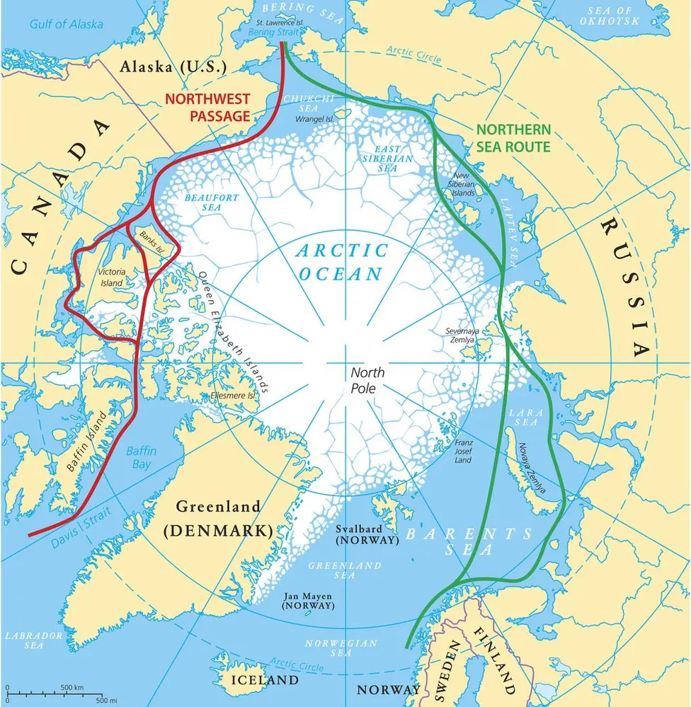
1.7 The Arctic route
The Arctic route breaks down into two main paths: the Northeast Passage, dominated by Russia, and the Northwest Passage, overseen by Canada.
Russia's Northeast Passage mainly hauls liquefied natural gas, while Canada's Northwest Passage—thanks to the tricky ice conditions in the Arctic Archipelago—hasn't yet taken off as a commercial route.
As global warming kicks in, the Northeast Passage's navigable season is set to stretch longer, turning it into a fresh hotspot in the geopolitical tug-of-war over Arctic pathways.
These critical sea routes work together to shape today's global trade patterns, and they'll keep evolving as global economics shift and climate change plays out.
If you pay attention, it's clear: whoever holds sway in the Middle East calls the shots on world trade.
2.Strategic significance of the Middle East's natural geographical barriers
The geography of the Middle East feels like a fortress crafted by nature itself. On land and sea, it's ringed by all sorts of natural barriers, shaping it into a central stronghold of the world—complete with its own security gates, barriers and moats.
2.1 Land barriers
2.1.1 Northwest
The Middle East's northwest flank is guarded by Turkey and the Caucasus Mountains, acting like a natural security gate keeping Europe and Russia in check.
The Caucasus Mountains, with an average elevation topping 3,000 meters and peaks blanketed in snow year-round, create a formidable barrier stretching hundreds of kilometers, much like a snowy version of the Great Wall. For Russia to push southward into the Middle East, they'd first have to cross these towering, snow-covered giants.
Turkey is particularly crucial, as it not only controls the Bosporus and Dardanelles straits—the only sea passages connecting the Black Sea to the Mediterranean—but is also backed by the rugged mountains of the Anatolian plateau.
This means that if European armies attempt to invade from the west, they will either be blocked by the strait or exhausted by the rugged terrain of the plateaus and mountains.
The Ottoman Empire was able to hold off European advances for centuries thanks to this terrain.
2.1.2 Northeast and east
In the northeastern and eastern reaches of the Middle East, the Hindu Kush and Sulaiman mountain ranges rise like a massive wall, splitting Central Asia from India.
Take the Hindu Kush in the northeast, for starters—its name in Persian translates to "kills the Hindu"—a rather ominous moniker.
This range towers at an average elevation of over 2,000 meters, its steep peaks and deep valleys pierced by just a handful of narrow passes. History backs up its reputation: Alexander the Great, marching east to India, and the British colonial army, pushing north into Central Asia, both were ambushed here. It's a natural trap, perfect for ambushes.
To the east, the Suleiman Mountains hug the Pakistan border, forming a solid divide between the Indian plains and the Central Asian steppes. If India ever wanted to stretch its territory northward, it would first need to tackle this towering mountain range.
Historically, India's influence has only stretched as far as the Pakistani frontier, with the lands beyond staying firmly out of reach.
2.1.3 Southwest
The Suez Canal and the Bab el-Mandeb Strait are vital links between Africa and the Middle East."
The Suez Canal connects the Mediterranean Sea to the Red Sea, letting ships travel from Europe to Asia without having to swing around the Cape of Good Hope. It's like a "toll station" for global trade.
The Mandeb Strait, with cliffs of Yemen and Somalia on either side, allows ships to pass only through its narrow middle. Whoever controls this strait controls a vital chokepoint for ships heading north from Africa.
2.2 Key Maritime Nodes and Internal Defenses
2.2.1 Maritime Strongholds
The Turkish peninsula stretches out like a giant hand into the Mediterranean, with Cyprus sitting like a shield in its palm. Together, they pretty much turn the eastern Mediterranean into Turkey's own backyard.
Back in the day, the Ottoman Empire relied on these two key spots to keep European navies pinned west of the Aegean Sea. Nowadays, Turkey's got a grip on northern Cyprus, still calling the shots in the eastern Mediterranean when it comes to shipping lanes and military moves.
2.2.2 Blockade for maritime trade
In the southern part of the Middle East, the Red Sea, the Gulf of Aden, and the Persian Gulf together form a critical blockade for maritime trade.
The Red Sea is like a tight corridor, connecting eastward to the Persian Gulf and westward through the Bab-el-Mandeb Strait to the Gulf of Aden and the Indian Ocean.
Picture the Red Sea as a security gate, with the Persian Gulf as a safe box—whoever controls this region holds the reins on the world's energy supply.
2.2.3 The Caspian Sea as a strategic moat
The Caspian Sea, sitting northeast of the Middle East, is a massive inland lake. To the north, it's flanked by the Central Asian steppes, and to the south lies the Iranian Plateau.
For the Middle East, the Caspian acts like a natural moat along its northern edge. On one hand, it blocks nomadic tribes from Central Asia from pushing south. On the other, countries along its coast, like Azerbaijan and Kazakhstan, serve as a buffer zone between the Middle East and Central Asia.

2.3 The Middle East's geostrategic advantages and the hurdles to regional unity
If Israel weren't in the Middle East, over twenty countries could come together to form a Middle Eastern alliance, fully tapping into the region's geographical strengths.
And if the Middle East can get its act together and unite, they might just bring back the golden era of the Arab or Ottoman Empires.
Unfortunately, the reality is pretty grim. The Middle East has been chopped up into a bunch of small nations, and with Israel constantly stirring up trouble, the region's defense system is basically toast.
Let's kick things off with Turkey. Turkey's got control of the straits, but Greece, to the west of Turkey, is a NATO member. They've got a ton of islands scattered across the Aegean Sea, and the closest one's only 10 kilometers from Turkey's shoreline.
If Turkey tries to block the strait, Greece's navy and air force can jump in fast, letting European powers get involved.
On the east side of the Suez Canal, you've got Egypt's Sinai Peninsula, and on the west, there's Sudan's Halayeb Triangle. These two countries are always bickering over this area.
If these two countries go to war, the southern defenses along the canal will be left unguarded, allowing African forces to exploit this gap and advance from the Red Sea, directly threatening the heartland of the Middle East.
Meanwhile, Russia's been parking troops in the Caucasus Mountains, claiming it's for peacekeeping. In fact, they aim to meddle in places like Syria.
So, the Middle East, which could have just relied on those mountain ranges to keep threats at bay, now has to station troops to keep an eye on Russia. That spreads their military thin.
Israel's got a lock on the Golan Heights, giving it a bird's-eye view straight into Damascus, Syria's capital. Plus, it controls the Jordan River's water source.
With a few fortifications and radar systems in place, Israel can keep tabs on every move its neighbors make. That forces Arab countries, especially Syria, to station a ton of troops in the south just to keep Israel in check.
Those soldiers are supposed to be guarding key mountain passes and straits across the Middle East. Instead, they have to fend off Israel, leaving the region's defenses vulnerable.
Besides outside influences, the Middle East's own internal problems make it tough for the region to come together.
Iran's the top dog for the Shia crowd, while Saudi Arabia's the big cheese for the Sunnis. These two have been slugging it out for over a thousand years—over religion, power.
Saudi Arabia's raking in cash hand over fist from oil, Turkey's itching to bring back the good old days of the Ottoman Empire, and Iran's on a mission to spread its religious influence far and wide.
All three love to throw around the word "unity," but none of them wants to take a back seat to the others.
The U.S. has a fleet in the Persian Gulf to protect "oil security; Russia has a military base in Syria; France has troops in North Africa.
It's as if three major powers have a stranglehold on the Middle East. Any country in the region that dares to spearhead unification efforts is immediately suppressed by a coordinated response.
Take Saddam Hussein and Muammar Gaddafi—they tried to fire up some grand Arab alliance, and the U.S. made sure that dream went down in flames.
3.Russia's strategic depth and its geopolitical quandaries
3.1 Strategic depth
Russia's got over 17 million square kilometers of land—picture the U.S. and Canada smashed together. That massive strategic depth is like a cheat code in warfare: Russia can trade space for time and just wear its enemies down.
3.1.1 Advantages of Russia's strategic depth
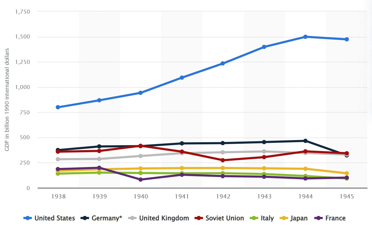
During World War II, the German army launched a blitzkrieg against the Soviet Union, reaching the gates of Moscow in just three months.
But Russia's sheer size turned the tables. The German supply lines got stretched out over thousands of kilometers, leaving tanks stranded without fuel and soldiers shivering in the brutal cold.
Meanwhile, the Soviets tapped into their massive rail network in Siberia, shipping in wave after wave of troops. In the end, they turned the tide and shoved the invaders right back.
Due to Russia's gigantic territory, the enemy's forces have to be dispersed.
In a typical scenario, with 100,000 troops, you could focus all of them on hitting one target hard. But in Russia, the situation changes dramatically. You have to divert 10,000 troops to safeguard your supply lines and another 20,000 to counter Russian guerrilla forces. As a result, you're left with only 70,000 troops to carry out the primary attack, reducing your offensive capability to just 70% of what it was initially.
Napoleon's army of 600,000 was down to just 30,000 by the time they got back to France.
3.1.2 Disadvantages of Russia's strategic depth
Russia's massive territory is a double-edged sword—it's so sprawling that it's impossible to keep both ends in check at the same time.
After the Cold War ended, countries like Poland, Lithuania, and Estonia—once part of the Soviet Union's sphere of influence—all became members of NATO.
Then, over a century later in 1941, Hitler's army followed the same playbook. Their lightning-fast blitzkrieg tore across that same plain, nearly swallowing Moscow whole.
If it hadn't been for the merciless Russian winter slamming the brakes on both invasions—and the sheer, sprawling size of the country—the Soviet Union might've been wiped off the map.
3.1.3 Ukraine: Russia's last line of defense
Russia needs a buffer zone on its western border. During the Soviet era, its strategy was to turn Eastern Europe into "satellite states."
But now, with those countries snuggling up to NATO, Russia's left with no choice but to zero in on Ukraine. If Ukraine joins NATO, it's like letting the enemy build a fortress right under your bedroom window.
The European part of Russia, including cities like Moscow and St. Petersburg, serves as the country's core region for population, economy, and politics. However, this area is flat, sitting on the East European Plain, and doesn't have any natural barriers.
That's why they lean hard on a buffer zone to hold the line, and Ukraine is the last line of defense.
Ukraine sits right on the front line of Russia's western border. From Ukraine's capital, Kyiv, to Moscow, it's all flat plains—tank units could roll through in just a few days.
So, if Ukraine were to join NATO, NATO could station missiles and radar systems there, leaving Russia's heartland exposed right under the enemy's gun.
Looking back at history, during the days of Tsarist Russia and the Soviet Union, Ukraine always served as their western buffer. In World War II, the Germans first took over Ukraine before pushing north to attack Moscow.
That's why Russia is now willing to fight a long, drawn-out war rather than let Ukraine fall into the West's camp. At its core, Russia is trading war for a safety buffer—even if it costs them dearly, they won't let the West hold a knife to their throat.

3.2 Russia's Current Geopolitical Challenges
3.2.1 North
Russia's northern edge hugs the Arctic Ocean, stretching over 20,000 kilometers of coastline. But for 9 months a year, it's a frozen wasteland, with temperatures diving to -50℃ in the harshest areas. A ship will be frozen into an ice sculpture the moment it set sail.
Back in the Soviet era, they tried to develop Arctic ports, pouring billions into building railways and infrastructure, but the brutal weather stopped them in their tracks.
3.2.2 Far East
Russia's Far East is enormous, sprawling over 6 million square kilometers—that's bigger than India. But there are only 6 million people and the infrastructure there is pretty rough.
Japan holds onto the Four Northern Islands. The US has military bases in Japan. From those bases, American fighter jets can zip over to Vladivostok in just 30 minutes.
The US and Japan have a strategy called "area denial." If Russian ships try to leave their ports, they'd be boxed in and targeted.
Take 2022, during the Russia-Ukraine war: Japan ran military drills on those islands, and all Russia could muster in response was a handful of aging warships.
3.2.3 Fleets
Russia's got five fleets on its roster: the Northern Fleet, Baltic Fleet, Black Sea Fleet, Pacific Fleet, and Caspian Fleet. On paper, they sound like a force to be reckoned with. In fact, each one's pretty much on its own when it comes to a fight.
The Baltic Fleet, for starters, is penned in by NATO countries to the west. Its only exit is the narrow Danish Straits, where NATO has more than a hundred radar stations. The second that fleet tries to slip out, it will be targeted.
The Black Sea Fleet has it even rougher. Turkey controls the Turkish Straits. If Turkey decides to close that door, the fleet will be trapped inside.
Then there's the Pacific Fleet, stationed in Vladivostok. It's got the frozen Sea of Okhotsk to the north and the Japanese archipelago to the south. If it ever needed to swing west, it'd have to take the route around the entire Asia-Pacific region. By the time it pulled into the Mediterranean, the war would already be over.
3.3 Russia's strategies
3.3.1 Strategies for the West
For Russia, having a buffer zone along its western edge is a must. The game plan hinges on using Belarus as a frontline shield, with Russian troops parked there to keep threats at bay.
The stretch between Minsk and Moscow is a tangled mess of forests and swamps, acting like a natural wire fence right at Russia's doorstep.
Back in 2020, when someone tried to take out Belarusian President Lukashenko, Russia didn't waste any time sending troops over there. They were worried about NATO getting a foothold.
If Ukraine joins NATO, ,NATO missiles could slam straight into Moscow's city center. That's why Russia's ready to destroy Ukraine rather than watch it cozy up to the West.
3.3.2 Strategies for the East
Russia knows it can't defend the Far East on its own. So, it offloads the pressure from the Pacific onto Beijing's shoulders.
The US-Japan alliance has its eyes locked on the Pacific, and Russia's Pacific Fleet just can't keep up. So, during the Sino-Russian joint patrol, Chinese warships are out front taking the heat, while Russia's basically just along for the ride, trying to look relevant.
Central Asia's five countries have long been Russia's "backyard," but China's been muscling in with its Belt and Road Initiative—building railways, power plants.
Russia's not happy about it, but it's got no choice but to accept it. After all, Central Asia's a long way from Moscow. Instead of spend money to hold onto it, Russia figures it's better to let China do the heavy lifting with development—as long as it keeps the U.S. from sticking its nose in.
3.3.3 Strategies for the South
Russia's southern strategy is all about securing the Mediterranean and the Caucasus.
Take Crimea, for instance: when Russia annexed it back in 2014, they essentially parked an unsinkable aircraft carrier smack in the middle of the Black Sea.
Fast forward to 2022, when the Russia-Ukraine war broke out. Russian forces lock down Crimea right away, because they terrified that NATO might snatch it up and slam the door shut on their southern access.
Meanwhile, Russia dive headfirst into the Syrian civil war, pouring billions into keeping their grip on the Tartus port. That base is their only naval outpost in the Mediterranean, sitting practically next door to Turkey, a NATO member.
3.4 New troubles for Russia's traditional geopolitical strategies
Russia used to leverage its enormous landmass to wear down its enemies, but as the global order shifts and warfare modernizes, it's now confronting 2 challenges.
3.4.1 The hypersonic missiles
The first challenge is hypersonic missiles, which make traditional buffer zones ineffective. Take the Tomahawk missile, for example. With a range of over 1,500 miles, it can strike Moscow directly from Poland.
In 2023, NATO set up a missile defense system in Romania, claiming it's there to counter Iran. But it's obviously aimed at Russia.

3.4.2 Economic globalization
Back in the day, Central Asian countries leaned on Russia to get by. But now China has constructed the China-Kyrgyzstan-Uzbekistan railway and the Central Asia natural gas pipeline. As a result, approximately 80% of Kazakhstan's wheat and Uzbekistan's cotton are now exported to China.
In today's era of economic globalization, traditional geopolitical strategies are becoming increasingly tough to pull off. A large territory is no longer an advantage.
For Russia, the real survival question is how to tackle NATO's containment efforts while strengthening ties with the East.
4.The European continent
4.1 The geopolitical landscape
Europe might look vast, but it's really just a big, open plain with no natural walls to hold it in. Its mountains are all scattered.
Take the West European Plain and the Po Valley, for example—both are flat. The Alps carve Europe into three big pieces: South, North, and East, while the Pyrenees draw a sharp line between France and Spain.
On top of that, Europe's coastline is more shredded than an old fishing net.
You've got the Iberian Peninsula holding Spain and Portugal, the Italian Peninsula with Italy, and the Balkan Peninsula packed with a bunch of small Southeast European countries. Add in islands like Britain and Iceland, and it's like Europe's been chopped into a million little squares.
Each peninsula and island is its own little world.
Ancient Greece, for example, used its location along the Aegean Sea to pioneer navigation and trade. Venice relied on the Adriatic Sea to develop trade. And Britain, positioned along the Atlantic Ocean, act as the maritime hegemon.
Land-based powers like France and Germany face a tough challenge when trying to unify because they first have to conquer the various peninsulas.
But the armies on those peninsulas are like naval guerrillas—striking here and there, which makes them really hard to deal with.
4.2 The importance of unity
Europe today is a crowded house with 27 countries packed into just 4.14 million square kilometers. If they don't stick together, they're left with no unified "market"—just a bunch of small and individual market.

Take Germany's cars, France's wine, or Italy's leather shoes. If each country started slapping tariffs on the others, costs would shoot through the roof, and they'd be totally outmatched by China and the US.
But thanks to the EU's unified tariffs and labor market, a German can work in France, and Spain can sell its fruit to Poland. It's like merging 27 small stores into one massive superstore, giving Europe a real shot at holding its own on the global stage.
With EU countries like Poland cozying up to the US and Hungary to Russia, it's easy for Russia to divide and conquer.
One day, Moscow might sweet-talk a country into cutting off its gas supply; the next, it could back another's push for independence. Before you know it, Europe's a total mess.
Look at 2022, when Russia rolled into Ukraine. The EU managed to hit back with unified sanctions because they stuck together. If every country had been scrambling for its own energy deals, they'd have been at each other's throats long before.
4.3 Britain's strategy
Britain sits across the English Channel, always ready to watch the chaos unfold without getting its hands dirty.
The Channel's narrowest point is just 34 kilometers. Big shots like the Spanish Armada, Napoleon, and Hitler all tried to cross it but failed.
Britain's strategy was to team up with the weaker countries on the European continent to take on whoever was the strongest player at the time.
For example, when France was flexing its muscles, Britain would buddy up with Russia to keep France in check. And when Germany was on the rise, Britain would join forces with France to push back against Germany. The whole point was to stop any single country from dominating Europe.
For Britain, the more fragmented Europe stayed, the better off Britain would be. If those countries ever got their act together and united, Britain would be sweating bullets.
In short, you could say Britain was Europe's ultimate troublemaker, always stirring the pot to keep things messy.

5.Japan and South Korea
Japan and South Korea both crave more independence from the United States, but they're careful not to ruffle any feathers.
Take Japan, for instance—it's itching to tweak its constitution to build a military, but the U.S. pushes back, worried about losing its grip on the Asia-Pacific region.
Japan's keen to ramp up trade with China, yet it's nervous about the U.S. slapping sanctions. So, Japan has left playing a balancing act, trying to keep things smooth with both sides.
6.China's geostrategic doctrine: harmonizing land and sea power
China's geopolitical strategy boils down to a hard-earned lesson: never let both the east and west flare up at the same time, and always keep an eye on both land and sea.
6.1 Historical humiliations and their geostrategic lessons
China's modern history is basically a story of total collapse on both land and sea.
The British kicked things off by blasting their way into coastal ports with warships, turning the southeast coast into a cash machine for foreign powers.
Meanwhile, Russia was busy carving up the north, snatching over a million square kilometers of territory in Outer Manchuria and even stirring up Mongolia's independence.
During the Cold War, China found itself in a tough spot.
The Korean War, where it had fought against American forces, had just wrapped up on its eastern front. Meanwhile, tensions were heating up with the Soviet Union along its western border. The Soviets had millions of troops lined up there, with tanks ready to roll into Beijing in just three days.
Faced with this threat, China had no choice but to dig in—literally—by building tunnels and stockpiling grain. The whole country shifted into a wartime mindset, and as a result, economic progress took a backseat.
As a country with both a long coastline and land borders, China cannot afford to engage in high-intensity conflicts on both its eastern and western fronts at the same time.
6.2 Land defense line
6.2.1 The Tibetan Plateau as a southwestern bulwark
In China's southwest, the Qinghai-Tibet Plateau—with its average elevation soaring above 4,000 meters—stands as a natural mountain shield against India.
The People's Liberation Army (PLA) has troops stationed in Tibet, giving them a front-row seat to peer down at India's northern plains. If India wants to push north, they've got to tackle the Himalayas first—a daunting climb.
Just look at the 2020 Galwan Valley clash: Indian forces were gasping for air in the oxygen-starved heights, showing how tough that terrain can be.
6.2.2 Mountain ranges and deserts shielding the northwest
China's northwest is locked down by a "firewall" of rugged landscapes, the Taklamakan Desert and Tianshan Mountains, that keep Central Asia's chaos at a safe distance.
Back in the day, China hold onto Xinjiang at all costs. If Xinjiang fell, Mongolia would be wide open, and enemies could charge straight to Beijing.
6.2.3 Strategic sponge
Up north, Outer Mongolia plays the role of a "strategic sponge" between China and Russia. Without it, Russian tanks could rumble right up to Inner Mongolia's border.

6.3 The key to maritime dominance
China's coastline is hemmed in by a C-shaped ring of U.S. military bases stretching from South Korea's Jeju Island down to Japan's Ryukyu Islands, Taiwan, and the Philippines.
Fighter jets can zip from Okinawa to Shanghai in just half an hour. And if the U.S. Navy sends in its carrier fleet, they could choke off 90% of China's trade routes in the South China Sea.
Both the Pearl River Delta and the Yangtze River Delta are within the range of U.S. firepower. So Taiwan, the Ryukyu Islands, and the South China Sea islands are of critical strategic importance to China.

Taiwan controls the Bashi Channel, a key route for aircraft carriers into the Pacific. Without Taiwan, China's navy would be stuck in coastal waters.
Then there's the Ryukyu Islands, just 600 kilometers from Shanghai—close enough to feel the heat. If U.S. bombers want to pound Shanghai, they've got to slip past the islands' early-warning radars and air defenses first.
Historically, the Ryukyu Islands were a tributary state of China, and although they are now under Japanese control, they remain of great importance to China.
The South China Sea handles 80% of China's energy imports.
6.4 China's geopolitical strategies
Out west, China's Belt and Road Initiative is laying down railroads and free-trade zones across Central Asia while cozying up to Russia. The goal? Turn the northwest into a secure "backyard" so unrest in Central Asia or a moody Moscow doesn't mess with the eastern game plan.
China's strategy in the east revolves around breaking through the island chain and asserting its maritime claims. This plays out through its ongoing dispute with Japan over the Diaoyu Islands in the East China Sea, its island-building efforts in the South China Sea, and its push to reunify with Taiwan.
7.America: from "isolationist" to "hegemonic burden"
America's history can be divided into two distinct phases: an isolationist period in the early 19th century and a global expansion phase that kicked off after World War II.
7.1 America's geographical edge
The United States enjoys a prime geographical position, with the Atlantic Ocean lining its eastern coast and the Pacific Ocean framing its west. Naval forces setting out from Eurasia would face the challenge of crossing thousands of kilometers of anti-submarine defenses. As a result, any attempt at a landing operation would be more than ten times as tough as the Normandy landings.
To the south lies Canada, whose military relies heavily on the U.S., and to the north, Mexico, whose economy is deeply intertwined with America's.
With no real threats on either flank, the U.S. doesn't need to deploy heavy army units. Instead, it can focus its resources on building a world-class navy and air force.
This unique setup makes America the only global power that doesn't have to worried about its own survival.
Even if a global nuclear war breaks out, the Rocky Mountains and the Central Plains would provide a fallback shelter.
7.2 Global expansion and "hegemonic burden"
After the War of 1812, no foreign enemy set foot on U.S. soil until Japan hit Pearl Harbor in 1941.
During World War II, the United States saw a dramatic rise in its overall national strength and started moving into a phase of global expansion. This shift involved adopting offshore balancing as a strategy, replacing its earlier approach of geographical isolation.
The United States is setting up military bases across Europe, Asia, and the Middle East while keeping a tight grip on critical sea lanes like the Malacca Strait and the Strait of Hormuz. At the same time, it taps into the SWIFT payment system to strengthen its global influence to some degree.
At the same time, America's role shifted from a producer to the keeper of global dominance.
When World War II ended, its industrial system was complete, fully capable of meeting its needs without leaning on foreign markets.
But as deindustrialization took hold, the U.S. had to step up to keep the world order intact, securing shipping lanes to protect its resource supply.
8.Australia: Pragmatic Strategies of a Resource-Rich Nation
Australia's situation perfectly illustrates how geography shapes strategy.
This country, locating in the Southern Hemisphere, is surrounded by vast oceans.
This isolated location provides a natural security buffer but also limits its military resources.
Sure, Australia's far from the world's major conflict zones, but it can't handle big security threats on its own.
That's why, since World War II, it's clung tightly to the US, relying on American military presence in the Asia-Pacific region for protection—it's like having a big brother.
On the flip side, when it comes to the economy, Australia can't ignore the giant market up north—China. As a resource-rich nation, Australia's got plenty to offer: minerals like iron ore and coal, plus top-notch agricultural goods like wool and beef. And China is the biggest buyer.

A few years ago during the pandemic, things got a bit rocky between Australia and China. China cut back on imports from Australia, and that hit a lot of industries hard. Mining companies saw their shipments drop, farms had produce piling up in warehouses, and even malls and tourist spots that rely on Chinese visitors were pretty quiet. It was clear that the economy was struggling.
But as relations warmed up over the past couple of years, exports bounced back. Mining companies started getting more orders, Australian produce returned to Chinese dinner tables, and the economy perked up.
Why does Australia depend so much on the Chinese market?
Well, it's pretty straightforward: their economy leans hard on selling raw materials and farm goods.
As China is the largest buyer of these goods, any dissatisfaction could significantly affect Australia's economy.
Australia leans on the US for military protection since its own defense capabilities are pretty limited. At the same time, its economy heavily relies on China's market.
So, it should keep its alliance with the US solid while making sure trade with China stays smooth. It can't afford to tick off either side.
Australia's geography and resources have pretty much laid out the smartest way for it to get by: stay neutral, keep out of the fray, and focus on selling its minerals and farm goods.
9.Geostrategy: the key to understanding global dynamics
The geopolitical strategies of the world's major powers aren't just pie-in-the-sky ideas. They're deeply tied to each nation's unique geography, historical baggage, and national ambitions.
It's like chess players plotting their moves on the board. Territory, resources, and power are the pieces they hold, while their development strategy is the game plan for facing challenges and driving growth.In the grand chessboard of global geopolitics, where do you think the next pivotal move will be made?